Babylonian world map: How ancient civilization viewed universe
In the British Museum in London collections, there is an extraordinary artefact known as Imago Mundi, or the "Babylonian Map of the World." Considered the oldest in the world, it was created approximately 2,600 to 2,900 years ago, during the height of the Neo-Babylonian Empire. Although its scientific accuracy cannot compare to today's tools like Google Maps, it provides unique insights into how ancient Babylonians viewed themselves and the world around them.
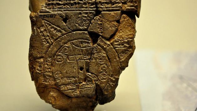


According to IFLScience, the map was discovered by the renowned archaeologist Hormuzd Rassam in the 19th century, along with other artefacts in Sippar, in present-day Iraq, about 40 kilometres southwest of modern-day Baghdad. The map is a 13 by 8-centimetre tablet depicting the land of Mesopotamia, considered the cradle of civilisation.
The oldest world map according to Babylonians
The map features Babylon and other significant cities and kingdoms of that period, all surrounded by an almost perfect circle symbolising the ocean. Scholars' discoveries also indicate that the map included descriptions of fantastic creatures such as a winged horse, a great sea dragon, or a man-bull, as well as historical figures such as Utnapishtim, the hero of the biblical flood story, and Sargon, the first ruler of the Akkadian Empire.
One area on the map is described as a place "where the Sun is not visible." As highlighted by IFLScience, Babylonians might have believed this to be a land of eternal darkness, similar to the dark areas described in the Epic of Gilgamesh. Another explanation could be that the map included a comment on the movement of the Sun.
Despite its archaeological and scientific value, the map would not be a practical navigation tool today. However, as Dr Irving Finkel, a British Museum expert, notes, it portrays Babylon as "tremendously extensive compared to other cities on the map," demonstrating that "the map’s content undoubtedly reflects Babylon as the centre of the world." This belief in Babylon's exceptional nature in the ancient world is a precious testament to past cultural beliefs.
This map remains a fascinating testimony to ancient knowledge and imagination, providing modern viewers a window into a long-lost world. According to IFLScience sources, it becomes an object of study and a bridge connecting the past era with the present.


